
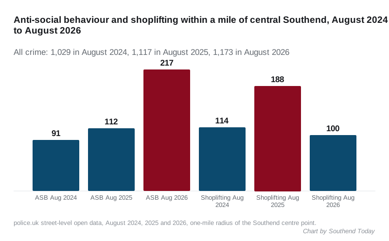
Police.uk logged 1,173 crimes within a mile of central Southend in August, up 5% on a year earlier. Anti-social behaviour 112 to 217; shoplifting 188 to 100.
Police recorded 1,173 crimes within a mile of the centre of Southend in August 2026, the highest August total in three years. Anti-social behaviour reports nearly doubled on a year earlier, while shoplifting almost halved.
The figures are the street-level open data that police.uk publishes for each month, read for a one-mile radius around the city centre (police.uk street-level crime data). That circle takes in the town centre, the central seafront and Prittlewell, roughly, and not the whole city. August is the latest month available.
August, three years running
| Aug 2024 | Aug 2025 | Aug 2026 | |
|---|---|---|---|
| All crime | 1,029 | 1,117 | 1,173 |
| Violence and sexual offences | 384 | 423 | 449 |
| Anti-social behaviour | 91 | 112 | 217 |
| Shoplifting | 114 | 188 | 100 |
| Public order | 104 | 74 | 81 |
| Criminal damage and arson | 66 | 80 | 72 |
| Drugs | 95 | 67 | 58 |
| Vehicle crime | 30 | 25 | 47 |
| Burglary | 22 | 13 | 22 |
| Possession of weapons | 9 | 14 | 11 |
The total is up 5% on August 2025 and 14% on August 2024. Two categories account for most of the movement in the last year:
- Anti-social behaviour went from 112 reports to 217, up 94%. ASB is recorded by the police but is not a crime, and police.uk publishes no outcome for it. It is also the category most sensitive to how a force records calls, so a jump this size can reflect recording practice as much as behaviour. Essex Police has not published a commentary on it.
- Shoplifting fell from 188 to 100, a 47% drop, after a 65% rise the year before. Supermarket and shop locations still feature heavily in the list below.
Vehicle crime, at 47, is nearly double August 2025. Burglary is back to the 2024 level after a low 2025. Drugs offences, which are mostly detected by police activity rather than reported by victims, have fallen for two years.
What was recorded in August
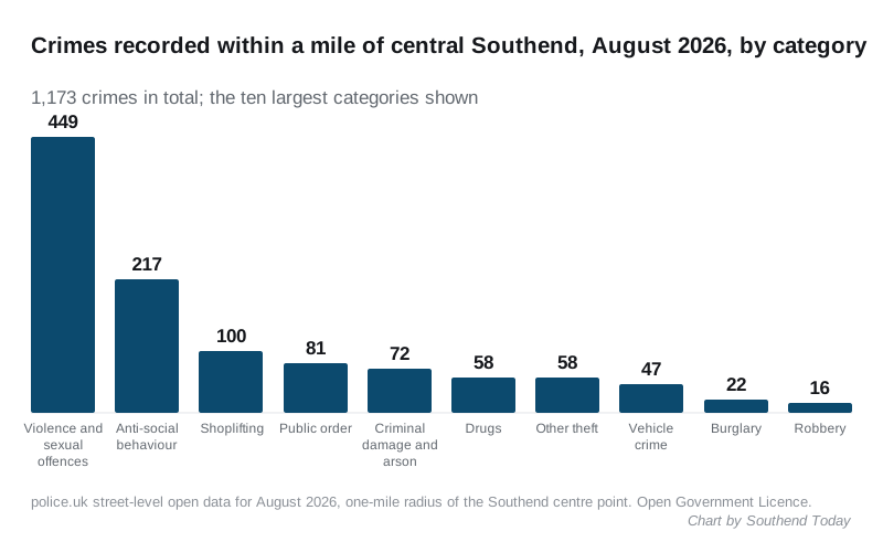
Violence and sexual offences, at 449, are 38% of everything recorded. That has been the pattern in every month of police.uk data we have checked for the town centre, and it is typical of a seafront town with a night-time economy. The category runs from common assault and harassment to the most serious offences, and police.uk does not split it.
Where
Police.uk places each report at the nearest of a fixed set of street points or landmarks, not at the address, so the labels below are approximate. The ten locations with the most reports in August:
| Location, as police.uk labels it | Reports |
|---|---|
| On or near Parking Area | 86 |
| On or near Nightclub | 65 |
| On or near Great Eastern Avenue | 56 |
| On or near Petrol Station | 48 |
| On or near Supermarket | 44 |
| On or near York Road | 25 |
| On or near Weston Road | 21 |
| On or near Deeping | 19 |
| On or near High Street | 19 |
| On or near Hamlet Court Road | 18 |
“Parking Area”, “Nightclub”, “Petrol Station” and “Supermarket” are police.uk’s generic landmark labels and can each cover several sites. Great Eastern Avenue, in the town centre, is the most-mapped named street.
What happened to the cases
Of the 956 crimes with an outcome field (ASB has none):
- 398 were still under investigation when the data was published
- 212 were closed because the police were unable to prosecute a suspect
- 207 were closed with no suspect identified
- 96 were awaiting a court outcome
- 24 ended in a local resolution
Outcomes are a snapshot: police.uk updates them in later months as investigations close, so the “under investigation” figure will fall.
What it means for you
A one-mile circle around the centre is the busiest part of the city for crime, and these numbers should not be read as a rate for Leigh, Thorpe Bay or Shoeburyness. To see your own street, enter a postcode on police.uk, where the same data is mapped.
The August data also carries the context for Friday’s arrest at Warrior Square, where officers recovered an imitation handgun: eleven possession of weapons offences were recorded within the mile in August, down from 24 in July.
We publish the police.uk figures for the centre each month when they are released, and the claimant count and house prices on the same basis.
Have your say